» » A Charles and Mieko Simon Web Site « «
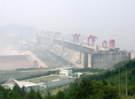
Seven thousand five hundred and seventy-five (7,575) feet in length and 610 feet tall — the colossal Three Gorges Dam is China's largest construction project since the Great Wall. Never before has a dam of such magnitude ever been attempted in the world. Constructing a dam on the Yangtze River was first envisioned in 1919. It wasn't until 1994 that construction began with a wall of steel and concrete that would consume 15 years and over $30 billion to build. When completed, the dam would contain twice the amount of concrete of the Itaipu Dam in Brazil, until the Three Gorges Dam, the world's largest. It will create a five-trillion-gallon reservoir hundreds of feet deep and about 385 miles long, The dam is designed to withstand and absorb a 7.0 earthquake. The Yangtze River will become a more navigable waterway, and protect the middle and lower reaches of the river from disastrous floods. As the world's largest hydro-electric power station by total capacity, which will be 22,500 mega watts, it is the equivalent electricity of 18 nuclear power plants. While all of these are huge numbers, consider that 1.9 million people were displaced, 2,000 villages and numerous archaeological sites were submerged.
The Dam is located near the mouth of the lowest of the Three Gorges, where the river current is divided by an island. In November 1997 the first stage was completed with the blocking of two-thirds of the river's width. The water level had risen 18 meters (59 feet) by the end of 1998, another further 52 meters (171 feet) by November, 2003. Thirty meters (98 feet) more will be added by 2009, and a final ten meters (33 feet) during 2009 when the dam will come into full operation. Smaller ships will use a single stage lift of the nature of an elevator and larger ships a five stepped lock. The waters in the Three Gorges will rise to a level of 175 meters (575 feet) when the dam is fully completed and the reservoir is filled. Gradually the scenery in the area will change. Later, there are photographs of where the 175 meter level is surveyed to be. Prior to our arrival, the water level had reached 156 meters and while we were there the level was 146 meters. This higher waterline can readily be seen in many of our photographs.
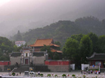
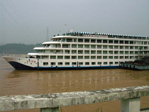
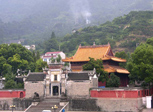
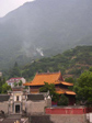
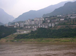
Our boat docking was at the Yellow Ox Temple, the temple with the orange roof tiles. It and the surrounding town was at the foot of some towering mountains. After breakfast we left for our bus tour of the Dam. Once again it was a hazy day, sure to be hot.


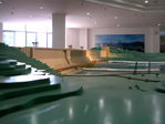
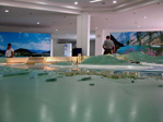
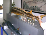
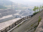
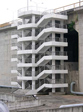
Our first stop was the Dam's Administration Building in the local town. Also situated in the immediate area were dormitories constructed for housing the many construction workers. The Administration Building housed a very interesting collection of photographs and models of the dam. The last photograph in the group below is a model of the turbine. To better understand the size of these turbines click here.


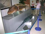
Below is a sturgeon caught in the Yangtze River. I had no idea that this fish as this big.
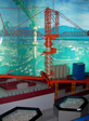
This is a model of the concrete placement setups. There were 12 of these and each consisted of a mixing plant, tower crane, conveyor belts and drop chute. Concrete placement continued for 3,000 days without stopping. Day and night, rain or shine, concrete continued to be mixed and placed. There were 35,600,000 cubic yards of concrete placed! The amount of steel used, 510,370 tons, was enough to build 63 Eiffel Towers! 13,400,000 cubic yards of earth was moved. An interesting detail writing of the concrete placement is found here.
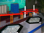
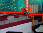
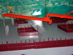
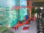
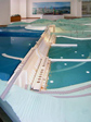
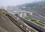
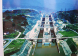
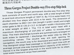
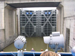
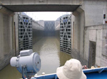
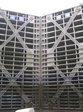
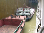
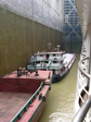
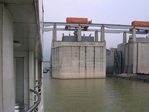
The first two photographs below are of the five stage locks. The third photograph is of the “ship elevator”. This is for smaller ships and lift the floating ship between lower most and uppermost water levels and vice versa, in one operation. Note the model ship in the lower part of the elevator. The model map of China has a ring of lights that show the area that power will eventually will be supplied.


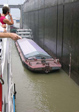
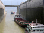
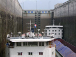
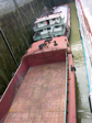
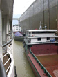
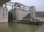
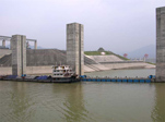
Finished looking at models, we made our way to the Dam. Our first close glimpse was the locks as some ships were entering for their trip upstream. The observation site is on the upstream side of the Dam. This first photograph of the Dam is of the reservoir side.
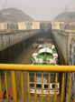
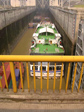
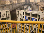
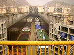
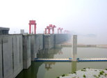
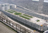
We were free to walk around anywhere at this stop. Also free to purchase a Magnum™ bar, a very good ice cream bar from Denmark. The observation point is situated where there is a good view of the locks, the ship elevator and both sides of the Dam. It was a nice area with even a funny sign.


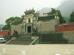
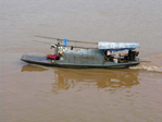
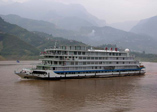
You should recognize the last of the above photographs, temple with the orange roof as being back at our boat. Relaxed for a bit in the VIP Lounge before going forward to watch our progress through the locks. Taking our turn going through the locks and then sailing through the Xiling Gorge.


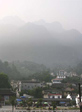
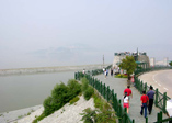
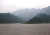
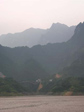
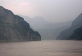
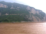
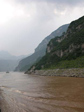
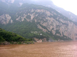
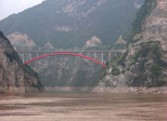
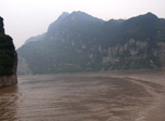
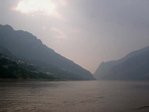
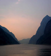
Xiling Gorge zigzags for 76 kilometers (47 miles). It is the longest and historically the most dangerous of the Yangtze gorges. Before the passage was made safe in the 1950s, the whole surface of the water was a swirling mass of whirlpools sucking the froth they created into their centers. Xiling comprised seven small gorges and two of the fiercest rapids in the stretch of the Yangtze between Chongqing and Yichang. The big dam is located in the middle of the Xiling Gorge and is now cutting it into two parts. A change of scenery has been made upstream the dam since November 2003, as the water had been rising some 52 meters(171 feet), submerging the lower part of the canyon. In these photographs you can see the 156 meter waterline at 10 meters above the current water level. On the upper side of the Dam, all the bridges, roads and towns are new resulting from the displacement of people and villages.


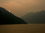
Some traditional Chinese music for entertainment after dinner. Also had a chance to grab a photograph of some of the Century Sun staff outside our cabin. For the remainder of the night we docked in Badong. We would enter the Wu Gorge in the early daylight hours of tomorrow. We saw no navigation aids on the Yangtze. That must have been the reason for not traveling through the gorge at night. The boat had a modern radar system and global position system but that hardly takes the place of a systematic arrangement of navigation lights for night travel.

